

Our Services
Deep domain expertise merged with advanced machine learning via interactive sector intelligence.
The Causal Foundation
Providing the data, insights, patterns, and methodologies businesses need to stay competitive in a physical world.
Water Security & Utilities
Ensuring security, quality, and supply continuity for public utilities.
Leak Detection: Computer vision and sensor-fusion AI to identify pipeline faults.
Quality Prediction: Early warning systems protecting public health standards.
Utility Demand Forecasting: Optimizing supply reservoirs during peak loads.
Asset Management: Centralized AI dashboards for complete visibility.


Energy & Grid Optimization
Balancing grid requirements and safeguarding vital assets through predictive intelligence.
Demand & Load Optimisation: AI forecasting to balance grids and prevent disruptions.
Predictive Maintenance: Advanced monitoring for turbines, solar arrays, and subsea pipelines.
Regulatory Automation: Streamline complex compliance reporting instantly.
Grid Optimisation: Anomaly detection to identify vulnerabilities before failure.


Extending asset lifecycles and mitigating complex project risks.
Predictive Maintenance: For bridges, roads, and civic public assets.
Risk & Cost Forecasting: AI simulations to accurately predict project overruns.
Automated Inspection: Processing drone/sensor data into integrity reports.
Digital Twins: AI-powered simulations to test scenarios without physical risk.
Public Infrastructure
Transportation and Logistics
Optimizing movement, pricing, and safety across global supply chains.
Route Optimisation: Real-time AI for fleet management and fuel reduction.
Fleet Maintenance: Predicting vehicle mechanical failures pre-emptively.
Freight Pricing: Dynamic tools for demand planning and yield management.
Passenger Forecasting: Aligning public transport deployment with commuter footfall.


Cross Sector Services That Work Across Every Vertical
Foundational AI capabilities that create value regardless of your industry.
Legacy Data Transformation
Turn decades of untapped operational data into AI-ready formats. Most infrastructure companies are sitting on a goldmine — we help you unlock it.
Custom AI assistants trained on your engineering documents, standards, and manuals. Instant answers for your teams, grounded in your domain knowledge.
Win more contracts with intelligent proposal generation. Our AI tools analyse winning patterns and craft compelling, compliant submissions.
Internal AI Assistants
AI-Powered Tender & Proposal Writing
Investor & ESG Reporting Automation
Automate investor reports, ESG disclosures, and regulatory filings. Consistent, accurate, and delivered on time — every time.
Projects
AI & Sensing
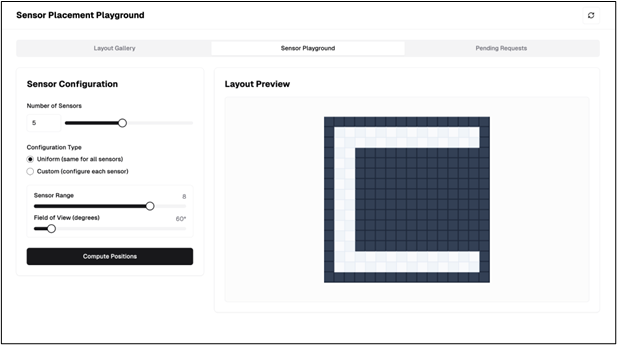
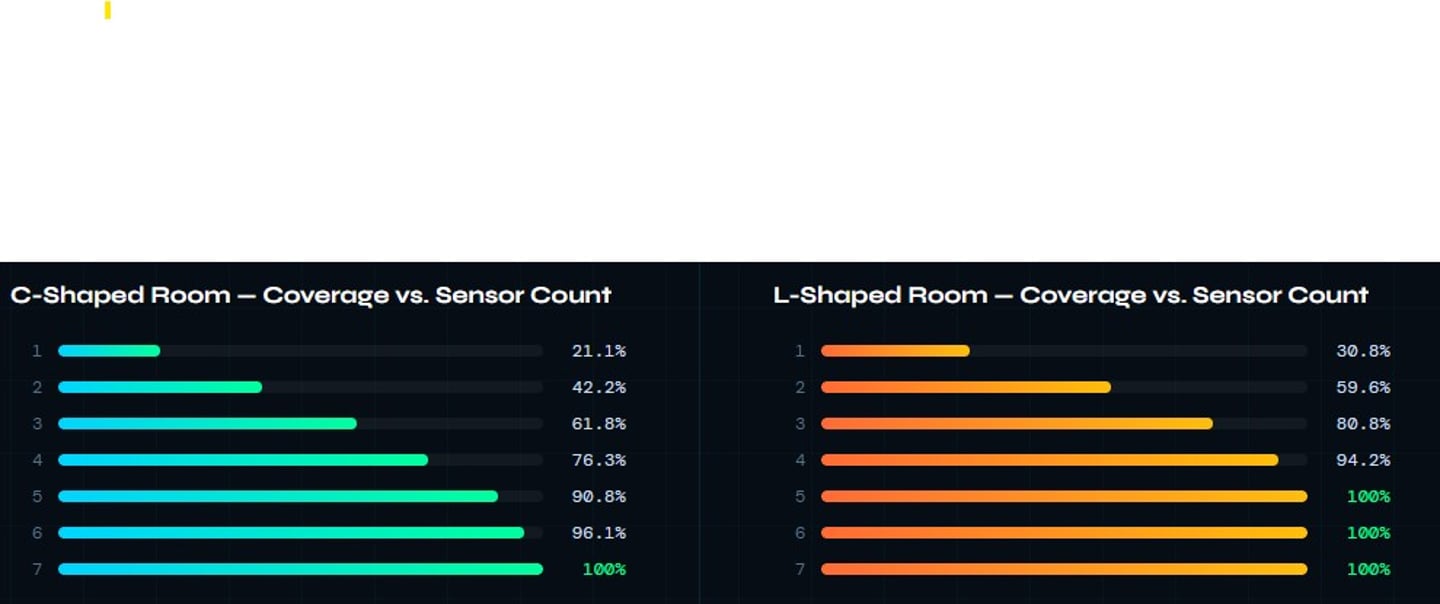
The Problem - Manual sensor placement doesn't scale
Placing sensors in complex indoor environments — with walls, furniture, irregular shapes, and overlapping zones is inefficient with traditional methods for Hazardous gas detection. We asked: Can an AI agent learn to do this autonomously?
How It Works
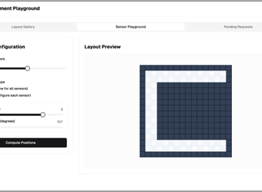
Design — User draws a 2D room layout and places obstacles on a configurable grid.
Configure — Sensor range and field-of-view are set before training.
Train — RL agent iterates over placements, rewarded for coverage and penalised for overlap.
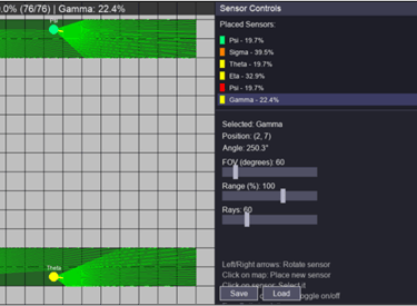
Visualise — Ray-traced FoV overlays show exactly what each sensor detects.
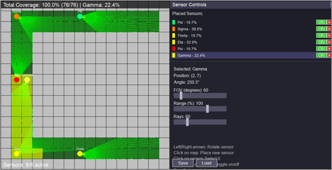
Sensor Placement Optimized by Reinforcement Learning
Reinforcement Learning Formulation
Framed as a Markov Decision Process — the agent observes the current layout, selects a placement coordinate, and receives a scalar reward balancing three objectives:
Coverage — reward for maximising detectable free space
Overlap — penalty for redundant sensor field-of-view intersection
Obstruction — penalty for placement blocked by walls or furniture
A ray-tracing mechanism casts detection paths from each sensor, tracking real-world occlusions for physical accuracy during policy learning.
AI & Computer Vision
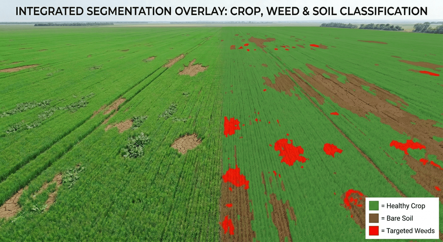
Implementing Semantic Segmentation for Targeted Herbicide Application
The Problem:
Our Client, a 5,000-hectare wheat producer, was uniformly spraying herbicides across all its fields. This traditional "broadcast spraying" method was incredibly expensive, environmentally taxing due to chemical runoff, and sometimes stressed healthy crops. They needed a way to identify exactly where the weeds were so they could spray only those spots.
The Solution:
Proposed computer vision pipeline using Semantic Segmentation. The goal was to classify every pixel in drone imagery into one of three categories: Wheat, Weed, or Soil.
Methodology:
Data Collection: Drones equipped with high-resolution RGB and Multispectral cameras flew over the fields at low altitudes, capturing gigabytes of overhead imagery.
Annotation: Agronomists manually labeled hundreds of images, creating "ground truth masks" by coloring crops green, weeds red, and soil black.
Model Training: The team utilized a deep learning architecture called U-Net (ideal for biomedical and agricultural segmentation). The model learned to distinguish weeds from wheat based on subtle differences in leaf shape, texture, and spectral reflectance.
Deployment: The trained model was integrated into the software of smart-tractors. As the tractor drove through the field, onboard cameras fed real-time video to the model.
Actuation: The segmentation model identified a weed patch in milliseconds and triggered specific sprayer nozzles to release a micro-dose of herbicide exactly on the weeds, turning off when passing over bare soil or healthy wheat.
The Results:
Cost Reduction: Herbicide usage dropped by 20%, saving the farm hundreds of thousands of dollars annually.
Environmental Impact: Chemical runoff into local water sources was drastically minimized.
Crop Health: Yield increased by 4% because the wheat no longer suffered from "herbicide burn" caused by unnecessary chemical exposure.